Just over one hundred years ago, a German meteorologist named Alfred Wegener presented a radical new concept to Europe’s leading geologists. He declared that ALL of the continents had, at some time in the past, existed as a SINGLE land-mass – a huge island which he called Pangaea.
He advanced the theory that both fossil, and geological evidence pointed to one single super-sized continent that existed about 250 million years ago – which, for unknown reasons, had broken apart -AND, that the pieces were still “drifting” away from each other!
He stated that our continents are moving – and have been for millions of years.
His discovery was NOT well received. But, since Darwin’s evolution-based concepts had recently shaken the academic community, a few more of the long-held views regarding Earth’s “provenance” suddenly became debatable. Wegener found that; – if it seemed hard to convince scientists and philosophers to move Man (and Earth) from the Center of their Universe – it was even harder to prove to geologists that the Earth was actually moving beneath their feet.
As with most early scientific theories, there have been some important technological discoveries made since Wegener’s passing, that would have made his case a little easier to present.
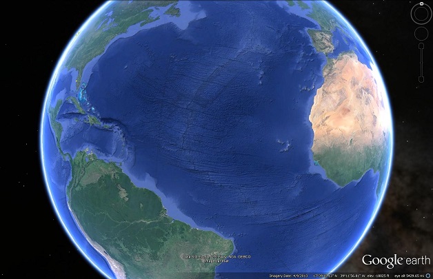
There had been little, to no, detailed research regarding the terrain of the world’s deeper sea-floors prior to the engineers who were laying trans-Atlantic telegraph cables across the Atlantic Ocean in the late 1800’s. They started reporting that there seemed to be “varying terrain” and deep trenches between the continents. Then, well over half a century later, the post-WW2 combination of sonar and submarines were put together as oceanographic tools – and an incredible landscape was revealed.
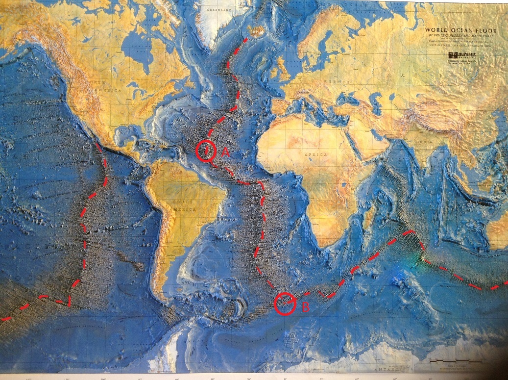
The new seismic data was analyzed by a cartographer named Marie Tharp, and her maps showed that, yes! Giant mountains existed almost exactly mid-way between the two continents!

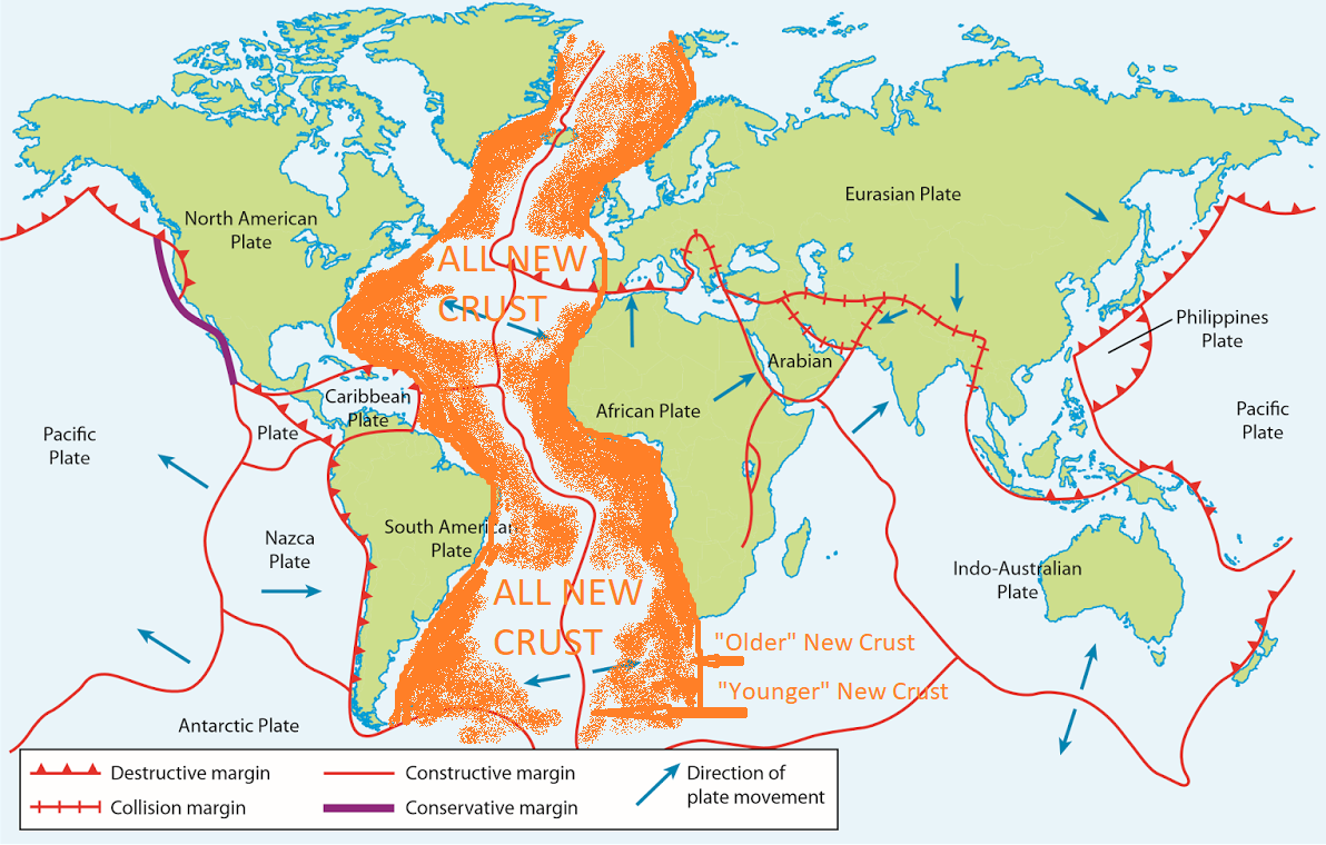
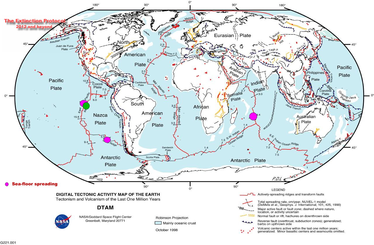
The Mid-Atlantic Ridge (hence, the MAR) is actually a 10,000 mile-long crack, running from South to North for almost the entire stretch of the Atlantic Ocean. Magma (basalt) constantly flows out of it in BOTH directions, creating mountains of basaltic debris on both sides at a fairly steady rate. All of the oceanic crust between Europe/Africa and The Americas has been created since the Pangaean split.
Now, satellite imagery from Google Earth provides remarkable detail of almost any part of the ocean floor you wish to peruse – amazing detail of the entire ocean landscape!
Earth’s thin Continental Plates “sit” upon the Earth’s original lava/oceanic crust, and are “pushed” away (along with the sub-surface material they rest upon) from the MAR center-line by new magma out-flow at the rate of a few inches per year – constantly “spreading” Africa and Europe away from North and South America (while other continents also spread away from each other!). And, by back-tracking the rate of spread, the math confirms Wegener’s time frame for the “original separation”.
But, the question of what caused Pangaea to break-apart 250 million years ago is still up for debate.
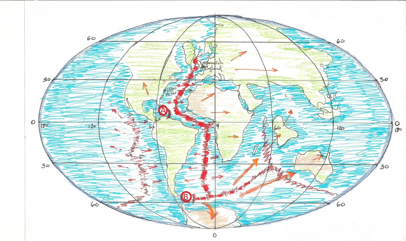
So first, let’s put Pangaea back together with the MAR as our guide – something Wegener could not do!
When we rebuild Pangaea with the MAR as a center-line, we see immediately that its land-mass became fractured along a very definite path. The continents “line-up” exactly over the MAR – the fissure not only penetrated the granite land-mass of the continents, but also the underlying sea-bed crust. Pangaea, and the underlying mantle, got cracked together! The mid-Atlantic Ridge is not a RIDGE – it is a RIFT.
But, what could cause such an event? – To crack through the granite continental layer and then miles deep into the Earth’s crust would need immense energy. The reigning current theories point to magma vortexes and currents that began underneath the mantle. These interior flows caused huge volcanic eruptions to swell up from deep inside the planet – ultimately tearing apart the land-masses into random “plates”, and then continuing the plate movements with subduction processes. While this is certainly not unreasonable, I have a different perspective to present.
What if, instead, the Earth was hit by Meteors? Not outlandish – the Earth is hit by meteors all the time. But, this time the event is much larger than the meteor of 65 million years ago that killed the dinosaurs – and much, much earlier; 200 million years earlier.
This is the timing for known “extinction events”:
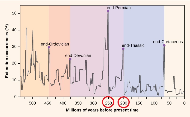
The chart above shows that a MAJOR extinction of life occurred at about the same time that Pangaea was breaking-up at 250 mya (the extinction occurred regardless of the reason for the destruction – eruptions or impacts), but it is obvious that this was an event even larger than the one that decimated the dinosaurs.
For me, there is compelling evidence that the destruction came from external sources.
I propose that one, or more, large meteors (or maybe pieces of a large comet passing by) happened to hit the Earth at the same time. I surmise that they were large enough to fully penetrate the Earth’s surface and leave impact craters so large that they essentially created their own tectonic plates.
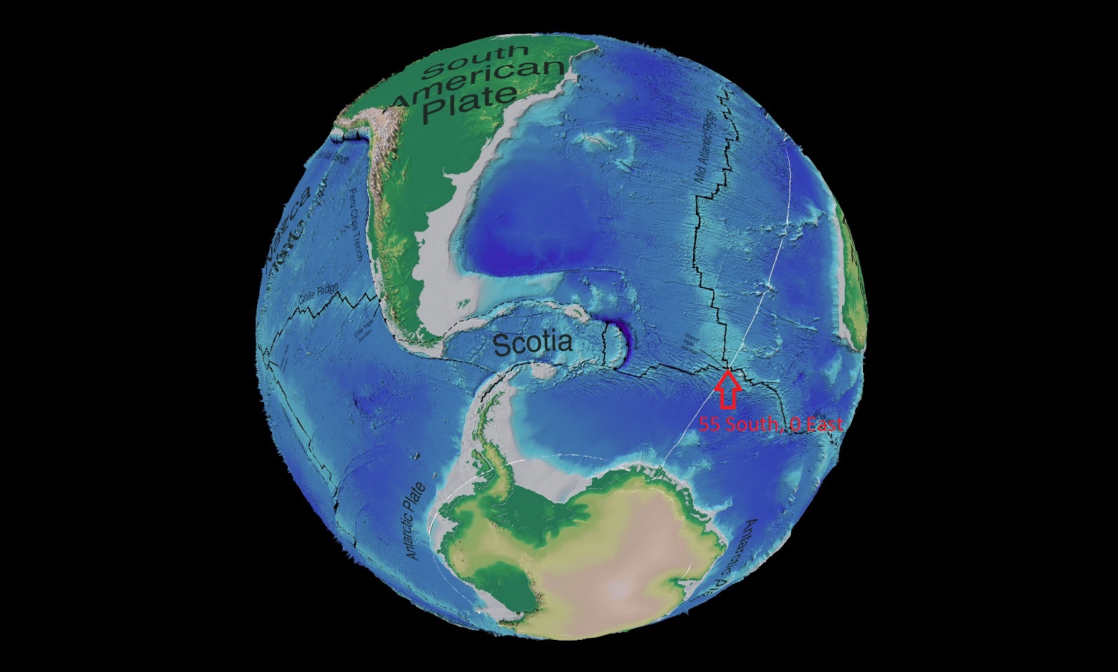
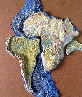
If the Caribbean and Scotia tectonic plates are moved back into their original positioning along the MAR – 250 million years ago, they both would have been located with their eastern edges placed exactly along what would eventually become the crack in Pangaea.
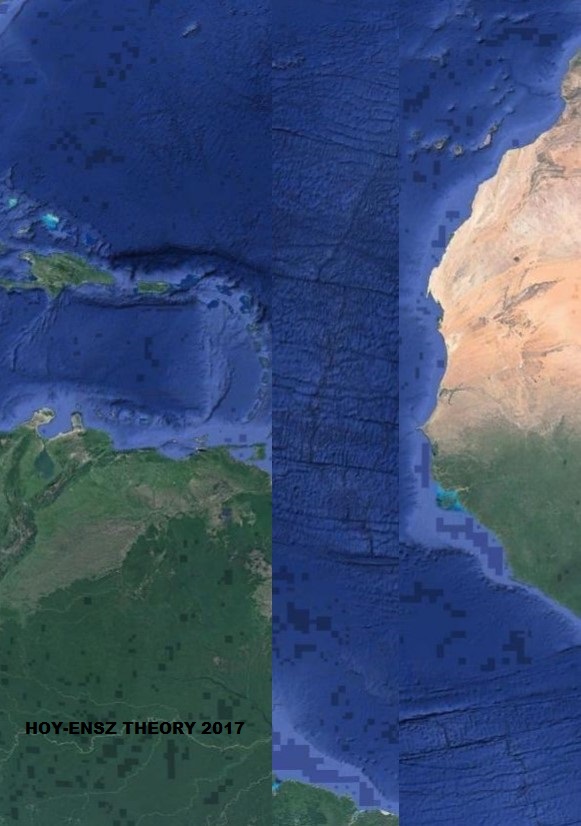
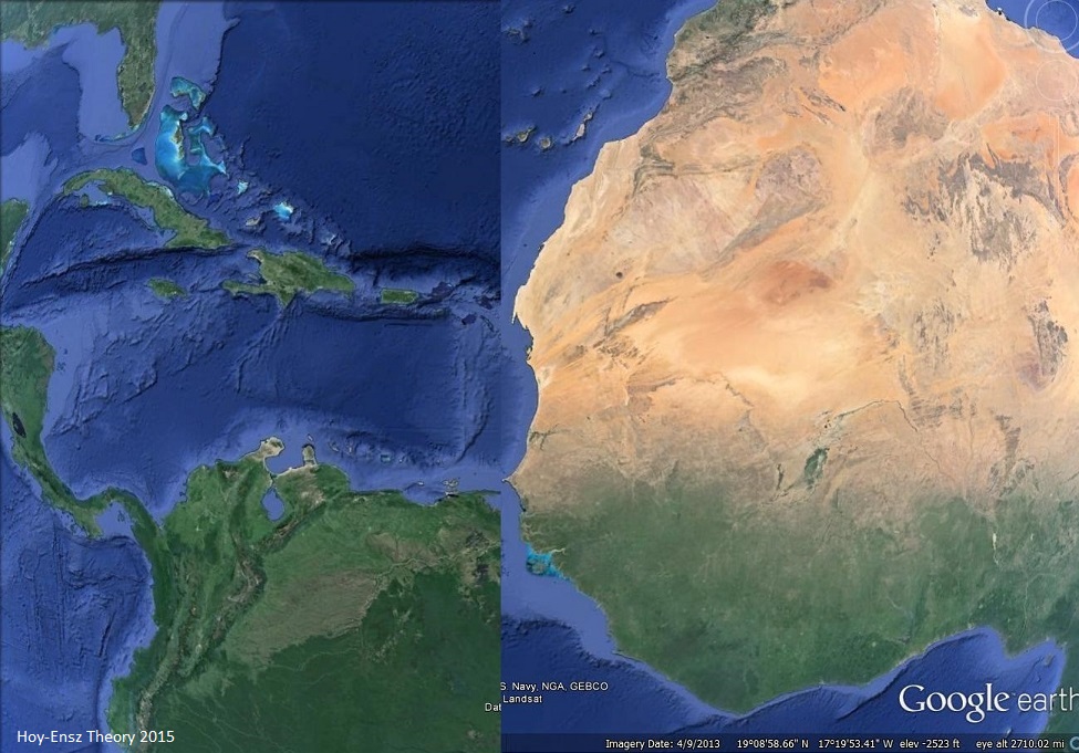

See how the Caribbean Plate lines up with the West Coast of Africa – all to scale! And, the Scotia Plate slots into Weddell Bay in Antarctica.
The event would have occurred like this:

These gigantic meteoric impacts would give a physical cause for a mid-Atlantic RIFT to occur. The devastation brought about by such huge collisions would have led to major extinction events. And, this rending of the Earth’s outer shell would necessarily give rise to the subduction zones that would be needed to off-set the ever-expanding, magma-oozing, crack that was created.
There is also evidence for a third impact area which would explain the movements of India and Australia much better than the current subduction models.
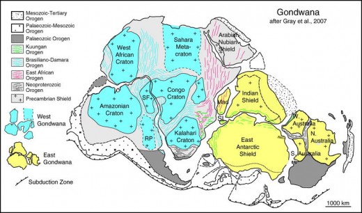
GONDWANA
The Southlands
The southern part of Pangaea, and it’s slightly different “break” from the huge land-mass, is of particular interest.
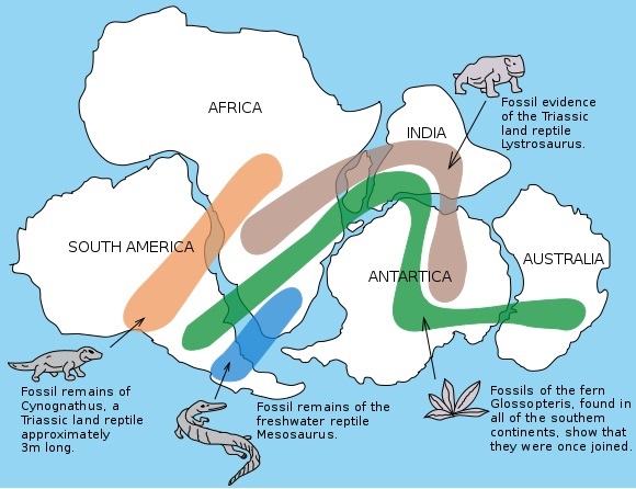
This is a fairly standard reconstruction of Gondwana, about 250 million years ago, based on fossil records:
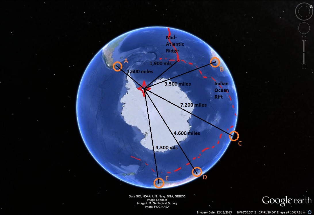
And, prior to its separation, the next illustration shows the distances across Gondwana/Antarctica to various future points of interest:

These continental plate movements continued over the next 250 million years, due mainly to the magma driven spreading of the MIR and the Indian Ocean Rift, and of course, they eventually end up at today’s current placements. But notice how much different the plates along the IOR (Indian Ocean Rift) have shifted versus the “simple” and “even” spreading of the MAR (Mid-Atlantic Rift). The MAR has added about 1,500 miles to each side of the central crack, while the IOR has only spread about a thousand miles – except in the case of India, which has moved more than twice that amount. (Note that Antarctica has also spun approximately 90 degrees!)
India’s “tectonic” movement begins to make more sense if a Third collision has occurred at (3) – which also happens to create Lake Victoria in Africa, AND give a reason for Antarctica’s “spin”:

THE RATIONALE
In its dark past, Earth was just like every other rocky accretion of meteors and celestial debris that happened to gravitate into a “planetoid”. It seems to occur often enough, as astronomers have now found thousands of little rocky planets lurking around various stars in our universe. It just so happens that most of them that are Earth-sized and below, tend to be unadorned rocky masses with hot centers (due to gravity continually pulling EVERYTHING towards its center – generating internal friction and heat), versus the larger planets having a tendency towards being gassy balls of vapor and dust! (Note: Harvard research recently uncovered a new class of planets that are about 4 times the size of Earth and are about 50% water! The water is in +900 degree steam-form, but it is water nonetheless.)
The point being that at some point Earth was like every other little rocky Venus-sized ball in the universe until 3 things occurred:
- It got a thin layer of liquid water (not steam or ice),
- It acquired a thin veneer of “land” (not impenetrable rock) on its surface, and
- It developed a crack all the way through the “land”, and deep enough into the mantle, to allow magma to ooze up from its hot core. The constant, forceful generation of new sea-floor oozing from the crack over the next 250 million years created subduction and volcanic activity in outlying areas where the original oceanic crust is forced underneath the lighter, thin layer of “land”. The land-masses that were split by the crack are shoved away from the original fissure, and each other, creating climate variations.
Regarding item number 1), the Water: There are guesses, theories, and hypothesis, but nothing concrete has been found. It would make sense that the water came from an external source – since the normal planetary rock-accretion process does not really allow water pockets to develop. And, along that line of thought, it would make sense that the water arrived prior to the development of multi-celled life-forms which generally seem to require oxygen and/or water – so, water probably arrived a little before 2 billion years ago. But, even though we may never know in what form, or original quantity it arrived – we do know it did occur –probably from either a close-proximity drenching, or a direct impact with a passing comet.
Then there is number 2) – How might “continental plates” have “grown” upon the Earth’s surface? Certainly there are many theories here also. Most of the current views involve multiple earlier incarnations of Pangaea existing as smaller “floating” islands that are “driven” (or actually sucked along) by subduction zones around the Earth’s crust – ultimately gathering randomly into a single land-mass.
The evidence against those theories would, for me, be numerous – First there is no evidence of any cracks in the Earth’s crust prior to our current Mid-Atlantic Rift (and its subsidiaries).
A “normal” older planetary surface, resulting from the slow, steady accumulation of nearby stellar debris (rocks) has a stone-strewn, gravely, dusty and cooler outer shell. Multiple “islands” being subducted around a planet exterior requires an incredible amount of heat very near the surface of the planet (implying an almost fluid-lava surface – which Earth was NOT at even 500 million years ago). Accretion with no atmosphere does not create surface fires.
The surfaces of Venus and Mars are not active lava beds, they are cooled, rocky and dusty landscapes that do not move – just as Earth would be if it did not have a DEEP, oozing rift around it (regardless of the presence of water!). The deep crack (the MAR) constantly emits magma and creates EXPANSION of our surface area! Gravitation fights the Earth’s expansion – so the offset is the “submergence” of some crust back into the interior mantle through weaker surface areas through subduction processes.
Cracks form “plates” (specific geographic sections) in the Earth’s crust – some of which are continental (granitic), and some of which are oceanic (basaltic). And, germane to my perspective, the reigning theories regarding the specific movement of the Caribbean Plate (both prior and post Pangaea) is, to say the least, highly speculative.
Of course, the above discourse only addresses the movement of the continents and the plates, not continental structure, or how they came to be. My theory reasons that Pangaea has ALWAYS been a singular land-mass. It is a large accidental accumulation of varied granite cratons in a relatively small (30%) area of the Earth. But, first, what are granite cratons, and why do they make a difference? And then, why might they all have accumulated in one area?
Granite is what makes up the “base”, or the bedrock, of ALL of the continental plates. Granite is a block of “normal” magma that has cooled at a different rate and pressure than all of the other magma around it, and has partially crystallized into a quartz/feldspar structure. This crystallization of the “rock/magma” acts much like adding “rebar” to concrete during construction – the longer crystals add stability to the underlying mineral composition. This new, stronger material is also now lighter than the average subsurface basaltic mixture, and can actually “float” above it! The granite that makes up the continents (and originally Pangaea) is not of a single slab like the granite on your counter-top, instead, most of the Earth’s granite pieces are just very large rocks (like the state of Texas-large). And, these Texas sized pieces, called cratons, all seem to have formed at nearly the same time frame about 3.5-4.5 billion years ago. Kind of like many, crumbled-up counter tops left in a pile to erode slowly over time.
Are there any new continents created since Pangaea? Have there even been any new Granite cratons or islands created since Pangaea? NO. Hawaii is basaltic and will eventually erode, as will ALL volcanic islands so far – as NONE of them are emitting granite. Nor have any new cratons broken through the oceanic or continental crust since Pangaea. Cratons are a SURFACE phenomenon.
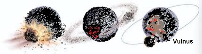
There was a theory presented about twenty years ago, which posits that a mars-size object (planetoid/asteroid/debris?), named Theia, delivered a glancing blow to Earth. The impact was not a direct hit, and the greater portion of Theia continued on, out into the further regions of space. But, a huge debris field is spun out for a few hundred thousand miles around the Earth. This event and resulting debris, which would have occurred at 4.5 to 3.5 billion years ago, ultimately coalesced into our Moon.
But given an event of this magnitude, there had to be a scar of some kind left on the Earth itself. I theorize that most of the debris that was compressed, then displaced by the impact returned almost immediately to the Earth’s surface – in, or near the impact scar area. Other debris that had been ejected from the Earth’s semi-cooled basaltic exterior gets thrown into “space” for just enough time to crystallize and become very large “chunks” of Granite before they return to the surface – I call this pre-Pangaean land Vulnus.
(As a tangent thought: Theia is also the “bringer of water” for Earth. And, the water it brings cools and crystallizes the impact debris into Granite. Either way, the silicate soils of the Earth’s continental plates, and the soils on Moon’s surface are of similar composition and point to a shared geological history.)
One might also surmise that, for an extremely extended period of time, huge chunks of Theia/Earth/Moon would be held in gravitational “limbo” between the Earth and Moon, and would occasionally fall back to Earth as very “slow”, but maybe extremely LARGE meteorites.
I propose that Pangaea is an accumulation of granite chunks that were all re-deposited in, and near, the area of an impact. The basic basaltic material of the Earth’s crust was transformed by this random, celestial, drive-by event into a large granite-infused scar.
*******
Imagine, Earth, about 4 billion years ago, as a ball of disparate rock and mineral aggregate, who’s outer shell has cooled to the consistency of a warm asphalt parking lot. Hot deep in the inside, but relatively cool on the outside. This “asphalt” proto-Earth is suddenly devastated, by a slightly smaller, but not dissimilar planetoid!
The collision ultimately creates the moon, but it also leaves a deep lava-filled scar. The scar eventually cools while gravitation re-rounds the Earth underneath it, but now the scar area is littered and filled with huge granite cratons that were formed during the collision.
A visual: The scar-collision area resembles a VERY thin “dinner-plate”-sized piece of granite that has now been stuck to the side of a wet asphalt basket-ball!
Billions of years go by as the impact debris coalesces and erodes, and the “asphalt-basketball with a dinner-plate stuck to its side” cools down to look much like Venus –but with a thin veneer of granite slabs covering an area where an impact had occurred long ago. AND, at some point in time, water arrives and covers the entire exterior crust of the planet JUST deep enough to leave the granite cratons exposed to whatever atmosphere existed at the time.
Much later, about 250 million years ago, the “dinner-plate” area of the planet, which now has evolved diverse plant and animal life on its surface (partly because eroded basalts and granite make great porous soils on which life can take hold) gets hit by two, or three large celestial objects.
Leading finally to 3) Regarding the Crack (the MAR) – My view would be that the Earth was only cracked ONCE, 250 million years ago, from an external meteoric event on land-mass called Pangaea. The fissures created by the impacts were deep enough to penetrate the granite island and the outer layer of oceanic crust as well. The original fissure is the mid-Atlantic Rift, which has never really stopped spreading, but the magma flow at the MAR has slowed to about half as much as the newer sections in the Pacific Ocean.
This is the Hoy-Ensz Theory.
If you re-align the pink and orange granite masses along the crack(s), Vulnus makes sense!
Below is “Point Zero” for Gondwana.